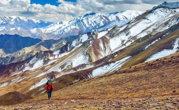
Laya Gasa trek. The Laya–Gasa Trek is considered one of the most scenic treks in Bhutan, offering amazing views of some of the most pristine and unspoiled landscapes. Every year in October, both locals and most of the tourists either trek or participate in the Laya Run which is yet another challenging and spectacular running. Laya Village in Bhutan is the home to the Layups. One of the smallest settlements in the Last Himalayan Kingdom, this remote village at an elevation of 3800m. The trek gives you the opportunity to camp at the village and explore the area.
Paro International Airport.
Starts from Punakha and ends at Punakha.
Moderate
4800 meter at Masangang Base Camp
110 km from the starting point to the end Point.


Fly onboard to Paro Bhutan. On a clear day, the panoramic views of the Himalayas are sensational, including Everest, but particularly exciting is the approach through the Bhutanese foothills and the landing, including a few steep, turns to land at the tiny airstrip of Paro. In Paro, you will be received by your Bhutanese guide and transferred to Thimphu (2 hours).
Overnight at Hotel Thimphu.
In the morning we drive to Punakha, the old winter capital. Leaving Thimphu the road climbs via a series of zigzags over the Dochu La Pass, 10,000ft/3,048m. On a clear day, panoramic views can be had of the eastern Himalayas, including Bhutan’s highest mountain, Gangkar Punsum, 24,770 ft/7,550 m. The road drops down through varied forests finally emerging into the highly-cultivated Punakha valley.
In the afternoon hike to Chimi Lhakhang, the divine mad monk’s temple. It is a beautiful walk through a lovely village. The temple can be visited and there is a tree outside which is supposed to have sprouted up after Drukpa Kunley sent a thunderbolt from an adjoining valley to kill some evil spirits who had gathered at the site. Also, visit Punakha Dzong situated on the confluence of two rivers.
Overnight at Meri Puensum Resort, Punakha
We drive to Damji ascending and descending through a heavily forested area and wild orchids. In this area, there are leeches so one must be careful too. Camp nearby village at an altitude of 2070m. Walking time 5/6 hours. Overnight at camp.
Walk for about half an hour over flat land till the Bele La pass. It’s down a hill all the way to Gasa Tshachu. Lunch at Gasa village at an altitude of 2,700m. After lunch walk through the homes of the village and watch beautiful Gasa dzong from the distance. The Dzong was built in the 17th century by the first religious King, Shabdrung Ngawang Namgyel, to protect the village from the Tibetan invaders. The ascend through Juniper and Fir forests until you reach the camp at Chamsa at an altitude of 30,80m. Walking time 6/7 hours. Overnight at camp.
Distance: 14Km
Walking time: 6/7 Hours
Max Altitude: 3800m
Ascend to the army camp and join the Mo Chu (mother river of Punakha). Follow the river till you cross the bridge. After the bridge, it is up and down several times, through Juniper and Fir forests. The walk to Laya is very pleasant with wonderful views. You will pass through dense forests, filled with Moss and Singing birds. Arrive at Laya village, the second-highest settlement in the country, at an altitude of 3,800m. Overnight at camp.
Explore the village. There are around 5 to 6 villages separated by names like Pazhi, Toko, Tongra. You can visit any house anytime and the owner will welcome you with sweet wheat wine. Even to a perfect stranger, traditional Bhutanese hospitality is extended and a cup of tea and Chang (local drink) is always offered.
The people in this village are interesting especially the women. They wear conical bamboo hats decorated with turquoise and silver ornaments. In the evening witness the cultural programs (dance) performed by village girls by the campfire and enjoy the local alcohol (Ara & Chang), if you have a strong stomach. Overnight at camp.
Distance: 12Km
Walking time: 4/5 Hours
Max Altitude: 4300m
After breakfast, we begin our beautiful trek. Along the way, you might come across a young girl singing while working on the field. Say goodbye and they might giggle you back. The trail Ascends another 500 m from Laya which will take a walking time of 4-5 hrs. Camp at an altitude of 4300 m. Overnight at camp.
Distance: 12Km
Walking time: 6/7 Hours
Max Altitude: 4800m
Climb another 500-600 m to reach Masagang base camp. Camp at an altitude of 4800 m. Overnight at camp. Masang Kang (also known as Masa Gang) is a mountain peak located at 7,194 m. The mountain peak is located in the catchment area of the Mo Chhu in Jigme Dorji National Park. The peak is 1.3 km south of the main Himalayan ridge, where the border between Bhutan and China runs. In its southeast, at 11.5 km Tsenda Kang 6,481 m (21,263 ft) rises and in its further east, at 18.75 km Tongshanjiabu 7,207 m (23,645 ft) is located. At the base, there is a trunk glacier that is 2km in length and fed by multiple tributaries
Distance: 10Km
Walking time: 4 Hours
Max Altitude: 4300m
Descend back to Gejepha/Gejethang. Camp at an altitude of 4300m. Walking time 4 hrs. Overnight at camp.
Distance: 10Km
Walking time: 3/4 Hours
Max Altitude: 3800m
Follow the same route back to Laya. Descend to camp at nearby Laya village at an altitude of 3800 m. Walking time 3-4 hrs. Overnight at camp.
Distance: 16Km
Walking time: 8/9 Hours
Max Altitude: 3800m
Descend to the army camp and join the Mo Chu( mother river of Punakha). Follow the river till you cross the bridge. After the bridge, it is up and down several times, through Juniper and Fir forests until you reach the camp at Chamsa at an altitude of 3,800m. Overnight at camp.
Distance: 12Km
Walking time: 5/6 Hours
Max Altitude: 2200m
Walk for about half an hour over flat land till the Bele La pass. Its down a hill all the way to Gasa Tshachu. Lunch at Gasa village at an altitude of 2,700m. After lunch visit the village and dzong The Dzong was built in the 17th century by the first religious King, Shabdrung Ngawang Namgyel, to protect the village from the Tibetan invaders. They descend to Gasa Tshachu (ht spring0for camps at an altitude of 2,200m. Overnight at camp.
Distance: 12Km
Walking time: 5/6 Hours
Max Altitude: 2200m
The path continues ascending and descending through heavily forested areas and wild orchids. In this area, there are leeches so one must be careful too. Camp nearby village at an altitude of 2,200m. Overnight at camp.
Our vehicle will drive you to Thimphu from Damji. In Thimphu visit the 13th arts and craft school/ folk heritage museam and BBS viewpoint from where you see Thimphu City.
Today city tour of Thimphu visiting the Memorial stupa of the late King built in 1974, Nunnery, the Traditional Medicine Institute where centuries-old indigenous medicines are still practiced, the National Library that houses ancient Buddhist texts and manuscripts, and hand made paper factory. Over night at Hotel.
After early breakfast in the hotel drive to Paro airport for flight to Bangkok/Kathmandu/Delhi.